In the last post, I covered the Detroit Terminal East Industrial Track, the eastern end of the railroad. In this post, we'll backtrack a bit and look at the Belt Line Industrial Track. In the Google Maps image at right, the Belt Line snakes southward just east of Hamtramck.
Here's a closer view of the Belt Line from Google satellite imagery. Just like the Detroit Terminal East Industrial Track and the Highland Park Industrial Track, we start near North Yard in Hamtramck. Just south of CP Bonita, a switch on the Detroit Terminal East Industrial Track provides access to the Belt Line just north of Lynch Road.
Almost immediately, the right-of-way enters Huber Yard, a small six-track yard near Chrysler's Lynch Road and West Warren plants. Continuing due south, two opposing switches serve Monarch Steel and Exel Distribution. The main line continues slightly more than a half mile before going through an S-curve, with spurs serving Ferrous Processing & Trading paralleling the right-of-way on the east side of the curve.
The line then continues to the south-southeast past the abandoned Packard Factory, which is possibly the poster child for what Detroiters call "Ruin Porn." Somewhat surprisingly, Integrated Packaging occupies space in a former Packard building on the west side of the tracks.
The line ends at Lagrasso Brothers Produce, which has buildings on both sides of the right-of-way.
In the image above, we're looking westward at the switch where the Belt Line diverges from the Detroit Terminal East Industrial Track. The switch in question is in the bottom left corner of this image, and the Belt Line continues straight to the south (to the left, from this perspective) while the Detroit Terminal line begins curving to the east. Just to the north is the Canadian National Crossing, and just to the west you can see North Yard.
Here is Huber Yard, a small six-track affair. The yard is essentially split down the middle, with the three tracks to the west providing storage and classification. Judging by the paved areas on each end of the three eastern tracks, autoracks are loaded here. This would be simple to model, since it is so compact.
Just across Huber Street (just visible at the right-hand edge of this image) are Exel Distribution and Monarch Steel. The large, nondescript building in the lower right-hand corner is Exel, while the building in the top left corner with the patchwork roof is Monarch Steel.
Here's how the switches serving Exel and Monarch are arranged, with the facing-point switch serving Monarch, and the trailing-point switch serving Exel. Georgia street poses one additional obstacle for crews switching Exel Distribution, requiring them to pull clear of the street before lining the switch, then laying on the horn while reversing up the spur. Also note the dilapidated fuel oil dealer just west of the Monarch spur, completed with rusty tanks just next to the building. Though not rail served, it would add a lot of character.
This is the business end of the spur serving Exel Distribution, a pair of rails disappearing through a roll-up door into the warehouse.
This would be a relatively easy industry to model, except that the Exel spur strays relatively far from the right-of-way for a shelf layout like I'm thinking about. A little selective compression could take care of that.
This is Monarch Steel. The building is run down, there are vacant lots surrounding the building, and it's not entirely clear that the place is still open. But, this is Detroit, and none of that means a thing.
I'm planning to model this scene, and it's a toss-up whether I'll model this as an active industry or not. The difference is that, as an active industry, Monarch Steel would add complexity to operations by requiring a run-around move to pull and spot cars. Any time I have the choice between having simpler or more complex operations, I'll choose complexity every time.
This is Ferrous Processing & Trading, a few blocks south of Monarch Steel. This operation is obviously alive and well, as you can see in the image to the right. Loads of scrap steel are delivered by gondola, shredded, melted down and turned into smaller, uniform-sized nuggets for use in the steel industry.
Here's a closer view, rotated 90 degrees from the image above, showing more detail of the track arrangment, and highlighting some interesting details. There's the main building, housing the furnace and other various heavy machinery, and just to the right, you can see some of the details of the shredding machinery. I also find some of the smaller details interesting, such as the small elevated structure between the two rail spurs that looks like a guard tower. Also, it looks like the operation has its own switcher, an Also S1 if you believe railpictures.net. That image was taken in 2008, and I'm not sure which paint scheme is more up-to-date, but the plain yellow seems easier to do!
This is Integrated Packaging Corporation, which occupies this large, fairly nondescript warehouse right across the tracks from the old Packard Motors Plant. This is the holy grail of ruin porn in the Detroit area. The Detroit Free Press just ran a large feature piece about this monstrous abandoned property. Having this hulking monument to urban decay as a backdrop would be one heck of a conversation piece. Integrated Packaging is just south of FP&T, across I-94.
A closer view of the main warehouse building shows a few 50' boxcars spotted on the rail spur, as well as some other interesting details, such as the large billboard just beyond the edge of the spur, and the large tank on the roof.
Continuing south across Grand Ave., the tracks continue past more of the old Packard plant, and there is a long passing siding here.
At the end of the passing siding, the rails cross Theodore St. and terminate at LaGrasso Brothers Produce. In the image to the left, you can see that LaGrasso Bros. occupies two buildings straddling the tracks, with a walkway connecting the buildings.
Here's a closer view, showing a white refrigerator car spotted at the loading dock.
Here we are, at the end of the line, both literally and figuratively. This image is from Google Street View, showing the LaGrasso Bros. spur as seen from Warren Ave.
This is the last of my series touring the Detroit Terminal, and I hope readers have enjoyed the ride. Those who know about the Contrail Detroit Shared Assets, or who have delved into Jeff Knorek's extensive website on the subject, will note that I have excluded the North Yard Branch/Sterling Secondary. I could make reasoned arguments about the fact that this was never part of the original DTRR's right-of-way, or the fact that it is so much longer than all of the other areas I've covered in previous posts. The fact of the matter is that these are just excuses, and I make no apologies other than to consider covering that portion in a later post.
The fact of the matter is that I started this project 10 months ago, and I'm itching to start turning all this information into an actual, working layout. So, in my next post, I'm planning to start narrowing down some choices and come up with a place to start. See you next time!
Showing posts with label Chrysler. Show all posts
Sunday, December 16, 2012
Friday, October 19, 2012
Detroit Terminal East Industrial Track
In the last post, we looked at the Highland Park Industrial track, located near the top edge of the Google Maps image to the right. Today, we'll continue moving clockwise and talk about the Detroit Terminal East Industrial Track. This is the longest stretch of original DTRR trackage still in use by Conrail today.
To the left is a Google satellite imagery showing a slightly closer view of the East Industrial Track. The line begins at the top left, at the same junction where the Highland Park Industrial track branches off from Conrail's North Yard Branch at CP Bonita. Once again, you may be able to see part of North Yard at the very edge of the photo.
The Detroit Terminal rails go south at first, then curve eastward at the junction with the Belt Line Industrial Track. More on the Belt Line in the next post. The line then heads southeast, past the other PVS Nolwood facility in Metro Detroit. You may recall the other facility is also served by Conrail on the Union Branch west of the city. Next up is the Chrysler Jefferson North plant, which is the real reason for the existence of the East Industrial Track. This Chrysler plant is Conrail's largest customer in the Detroit area, according to a recent article in the October 2012 issue of Trains magazine. The line continues southeast toward the Detroit River, serving two smaller industries before reaching the water's edge.
We're back at CP Bonita in the photo above, the intersection of North Yard (top left), the Highland Park Industrial track (top right), the North Yard Branch (bottom right) and the Detroit Terminal Industrial Track (bottom left). For reference, North is to the right in this image.
Moving south slightly, there are a few interesting items to note in the image to the right. First, there's the small classification yard near the top of the photo, which is the northern end of North Yard. The tracks farthest from the camera appear to be RIP tracks, judging from the cars spaced out so that workmen can perform repairs. Second, there's the crossing just below the yard, where the East Industrial Track crosses the Canadian National Mount Clemens Subdivision. The East Industrial Track runs straight north-south, and the CN runs diagonally across.
Once again, we move southward slightly (that's the East Industrial Track/CN crossing at the right) and we see the switch where the Belt Line Industrial Track begins. It continues directly to the south, while the East Industrial Track begins curving eastward.
Moving a couple miles eastward, this is the old Hudson Motors Gratiot Avenue plant. There are rail spurs there in the weeds, but they've been out of use for a long time.
Right next door to the old Hudson plant is the PVS Nolwood plant, as noted earlier, the second of two in the Detroit area and both served by Conrail (or, in my version of reality, the Detroit Terminal). To the left is a Google satellite image in which I've highlighted all of the tracks serving the plant. In this overview, you can see the spurs on both sides of the main line.
Here's a closer view from Bing Maps, facing south to better show the trackage at the back of the plant. It's a fairly complex layout, involving several switchbacks in a confined space. Here are a couple even closer views:
Above, you can see the complex switchbacks at the rear of the complex, and to the left, three additional spots just around the corner.
Here's the other half of the PVS Nolwood operation on the east side of the Conrail main line. There's probably more trackage than on the west side, but it's less complex. What we have here are a couple load out spots next to the white storage tanks and a small yard to store and sort cars for the whole PVS operation.
The way the whole PVS Nolwood operation fans out from the main line, this industry could be challenging to model. However, the operational complexity would make a big contribution to the overall operations of the model railroad, so this is a priority to include.
Continuing southeast toward the river, there is this neat triangular building at the intersection of St. Jean and Shoemaker. It may or may not have been rail served at one time, but that's not really the point. Given the space and time, it's going on the layout.
Next up is Mack Yard and Chrysler's Jefferson North Plant. As noted earlier, this is Conrail Shared Assets' largest customer in Detroit. Jeep Grand Cherokees and Dodge Durangos are built here and shipped out to the rest of the world via autoracks. In the image at right, the factory buildings immediately to the east of Mack Yard are actually the old Budd Co. factory, most recently purchased by Thyssen Krupp and shuttered in 2006.
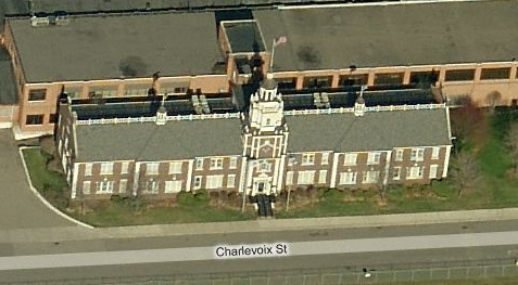
One interesting note is that the original builder of this factory, the Liberty Motor Company, built a replica of Philadelphia's Liberty Hall as it's front offices. The building still fronts Charlevoix St.
In the photo above, we're looking east over Mack Yard with the Budd plant just beyond. The first eleven tracks - those closest to the Budd plant - appear to be used for storage and some minor classification. The next eleven tracks - split into a group of four and then another seven - are dedicated to loading the autoracks. You can also see tracks curving away from Mack Yard to the west, which as you can see in the overview of the entire plant above, hem in the west edge of the Chrysler property. Two of the three tracks bordering the property appear to be used for storage, while one continues south.
Here we have two industries. The large warehouse on the right is Syncrean U.S., and (barely visible) to the left is PSC Environmental Services. There's not much information out there about Syncrean, other than they specialize in logistics for the auto industry. This facility appears to be some kind of transloading facility, with a rail spur entering the warehouse at the north end, and truck docks all around.
This is PSC Environmental Services, who provide hazardous materials clean-up, transportation & disposal. What you see here is what you get - a dilapidated storage building, a couple rudimentary metal shelters and two tank car load-outs. Easy & simple to model, and absolutely oozing character. This is definitely an industry I'd like to include on the Detroit Terminal model.
Before the rails disappear in the weeds at the edge of the Detroit River, we have this interesting little boat yard. As a sailor, this is another detail I'd like to model, given the space.
With that, our tour of the Detroit Terminal East Industrial Track comes to a close. Next up, we'll look at the Belt Line Industrial Track.
To the left is a Google satellite imagery showing a slightly closer view of the East Industrial Track. The line begins at the top left, at the same junction where the Highland Park Industrial track branches off from Conrail's North Yard Branch at CP Bonita. Once again, you may be able to see part of North Yard at the very edge of the photo.
The Detroit Terminal rails go south at first, then curve eastward at the junction with the Belt Line Industrial Track. More on the Belt Line in the next post. The line then heads southeast, past the other PVS Nolwood facility in Metro Detroit. You may recall the other facility is also served by Conrail on the Union Branch west of the city. Next up is the Chrysler Jefferson North plant, which is the real reason for the existence of the East Industrial Track. This Chrysler plant is Conrail's largest customer in the Detroit area, according to a recent article in the October 2012 issue of Trains magazine. The line continues southeast toward the Detroit River, serving two smaller industries before reaching the water's edge.
We're back at CP Bonita in the photo above, the intersection of North Yard (top left), the Highland Park Industrial track (top right), the North Yard Branch (bottom right) and the Detroit Terminal Industrial Track (bottom left). For reference, North is to the right in this image.
Moving south slightly, there are a few interesting items to note in the image to the right. First, there's the small classification yard near the top of the photo, which is the northern end of North Yard. The tracks farthest from the camera appear to be RIP tracks, judging from the cars spaced out so that workmen can perform repairs. Second, there's the crossing just below the yard, where the East Industrial Track crosses the Canadian National Mount Clemens Subdivision. The East Industrial Track runs straight north-south, and the CN runs diagonally across.
Once again, we move southward slightly (that's the East Industrial Track/CN crossing at the right) and we see the switch where the Belt Line Industrial Track begins. It continues directly to the south, while the East Industrial Track begins curving eastward.
Moving a couple miles eastward, this is the old Hudson Motors Gratiot Avenue plant. There are rail spurs there in the weeds, but they've been out of use for a long time.
Right next door to the old Hudson plant is the PVS Nolwood plant, as noted earlier, the second of two in the Detroit area and both served by Conrail (or, in my version of reality, the Detroit Terminal). To the left is a Google satellite image in which I've highlighted all of the tracks serving the plant. In this overview, you can see the spurs on both sides of the main line.
Here's a closer view from Bing Maps, facing south to better show the trackage at the back of the plant. It's a fairly complex layout, involving several switchbacks in a confined space. Here are a couple even closer views:
Above, you can see the complex switchbacks at the rear of the complex, and to the left, three additional spots just around the corner.
Here's the other half of the PVS Nolwood operation on the east side of the Conrail main line. There's probably more trackage than on the west side, but it's less complex. What we have here are a couple load out spots next to the white storage tanks and a small yard to store and sort cars for the whole PVS operation.
The way the whole PVS Nolwood operation fans out from the main line, this industry could be challenging to model. However, the operational complexity would make a big contribution to the overall operations of the model railroad, so this is a priority to include.
Continuing southeast toward the river, there is this neat triangular building at the intersection of St. Jean and Shoemaker. It may or may not have been rail served at one time, but that's not really the point. Given the space and time, it's going on the layout.
Next up is Mack Yard and Chrysler's Jefferson North Plant. As noted earlier, this is Conrail Shared Assets' largest customer in Detroit. Jeep Grand Cherokees and Dodge Durangos are built here and shipped out to the rest of the world via autoracks. In the image at right, the factory buildings immediately to the east of Mack Yard are actually the old Budd Co. factory, most recently purchased by Thyssen Krupp and shuttered in 2006.
One interesting note is that the original builder of this factory, the Liberty Motor Company, built a replica of Philadelphia's Liberty Hall as it's front offices. The building still fronts Charlevoix St.
In the photo above, we're looking east over Mack Yard with the Budd plant just beyond. The first eleven tracks - those closest to the Budd plant - appear to be used for storage and some minor classification. The next eleven tracks - split into a group of four and then another seven - are dedicated to loading the autoracks. You can also see tracks curving away from Mack Yard to the west, which as you can see in the overview of the entire plant above, hem in the west edge of the Chrysler property. Two of the three tracks bordering the property appear to be used for storage, while one continues south.
Here we have two industries. The large warehouse on the right is Syncrean U.S., and (barely visible) to the left is PSC Environmental Services. There's not much information out there about Syncrean, other than they specialize in logistics for the auto industry. This facility appears to be some kind of transloading facility, with a rail spur entering the warehouse at the north end, and truck docks all around.
This is PSC Environmental Services, who provide hazardous materials clean-up, transportation & disposal. What you see here is what you get - a dilapidated storage building, a couple rudimentary metal shelters and two tank car load-outs. Easy & simple to model, and absolutely oozing character. This is definitely an industry I'd like to include on the Detroit Terminal model.
Before the rails disappear in the weeds at the edge of the Detroit River, we have this interesting little boat yard. As a sailor, this is another detail I'd like to model, given the space.
With that, our tour of the Detroit Terminal East Industrial Track comes to a close. Next up, we'll look at the Belt Line Industrial Track.
Labels:
Budd Co,
Canadian National,
Chrysler,
Conrail,
Detroit Terminal Railroad,
East Industrial Track,
Hudson Motors,
Jefferson North,
Liberty Hall,
Mack Yard,
North Yard,
PVS Nolwood,
RIP track,
Shared Assets
Thursday, April 26, 2012
The Dearborn Industrial Track
Let's take a look at perhaps the shortest portion of my modern day Detroit Terminal Railroad, the Dearborn Industrial Track.
On the map to the left, the Dearborn Industrial Track (DIT) is the short, curved line on the bottom left.
To the right is a closer view using Google Maps satellite imagery. The route begins with a switch off the Conrail Michigan line, called CP Lou. For reference, the wye at the northern end of the Junction Yard Secondary (covered in the last post) is a couple miles to the west of here, diverging off the same rails. The switch at CP Lou provides a connection to the CSX Detroit Subdivision which Conrail uses - via trackage rights - to access the DIT. A few miles north, another switch provides access to the DIT proper. Dearborn Steel is just after the right-of-way curves eastward, and Kenwal Steel is at the end of the line.
Everything north of the switch off the CSX Detroit Sub was once the main line of the original Detroit Terminal Railroad. North of Kenwal Steel, the line continued directly north until it reached Lyndon St./Livernois Ave., where it veered northeast toward Highland Park.
Where the DIT joins CSX rails today, there used to be crossing at grade and the DTRR continued south to Rougemere yard. In the image below, the red line represents the DTRR's abandoned right-of-way:
This rail line was torn up after Conrail purchased the DTRR, and from a modeling perspective, I can easily live without it. There aren't any industries off this portion of the DTRR, and while the interchange with CSX at Rougemere Yard would be interesting to model, it would also take a lot of space.
This is CP Lou, the Conrail interchange with CSX. The switch near the top right of the photo is what provides access to CSX rails via the curved spur. Twin truss bridges carry the CSX right-of-way over the Conrail Michigan Line, and immediately west of them is a plate girder bridge which used to carry the DTRR. I have seen this area firsthand driving along Southern Street, and those bridges are a favored target for graffiti taggers:
The Google camera vehicle is between the CSX bridges on the left and the abandoned DTRR bridge on the right. We're looking south here.
Here we have XCEL Steel Processing, the first industry served by the DIT. A web search produces a website, but not much info. Judging from the photos on their site and the satellite images from Bing and Google, it's pretty clear that they ship steel coils, and that's just about all we need to know.
A closeup of the rail spur reveals empty gondolas and coil cars being loaded by a traveling crane. Litter some steel coils around, throw an image of the XCEL building onto the backdrop, and I think we have a model!
Here's where the Conrail spur joins the CSX Detroit Sub on a bridge over I-94. The bridge just to the south used to carry the original DTRR.
In the picture to the right, I've rotated the image so that we're looking east along Michigan Ave. I-94 is to the south, off-picture to the right. That's CSX running from top right to bottom left, and you can see the switch where the DIT begins in the top right corner. You can also see the old, abandoned DTRR right-of-way and the bridge where it used to pass over Michigan Ave. before crossing the CSX line.
Here's a picture courtesy of Google Streetview, taken from between the abandoned DTRR bridge on the left and the CSX bridge on the right.
Just north of Michigan Ave. is this old tank farm. You can see the switch on the left side of the photo, and the spur that goes a full 180 degrees to serve some long-gone industry. This spur may very well have served the tank farm.
For modeling purposes, I think this could be an interesting scene to model as an abandoned industry, especially since the switch still exists in real life. It would be great backdrop fodder, if nothing else.
There's not much more of interest until the right-of-way curves 90 degrees due east and we get to Dearborn Steel on Wyoming Avenue. The company's LinkedIn profile indicates they specialize in steel coils, break bulk metals, aluminum and packaging.
What you see here is a runaround track and two storage tracks along the DIT right-of-way. The Bing Maps images show coil cars exclusively, but Google Maps shows some 50' boxcars:
Conrail crews shuffle cars here before switching the in-plant trackage which you can see in the photos above. I would only plan to model the small yard, using the tall grass just to the north to hide the spur going behind the backdrop.
This was once the Chrysler Brant Street plant. It hasn't been rail served for many, many years, but might be interesting backdrop fodder. The DIT is actually double-track past here, or more accurately, one big runaround track.
Just east of the Chrysler Brant Street plant - just across Lonyo St. as a matter of fact - is Kenwal Steel. The plant occupies the area where the DTRR's Lonyo Yard used to be. That yard was used to serve Chrysler's West Warren Plant. That building still stands today, and in fact you can just see it in the top left corner of the image at right.
I once parked just south of the DIT track at the Lonyo Ave. crossing, hoping to get some photos of Kenwal Steel. Imagine my delight when I suddenly heard a telltale diesel thrum and then air horns! Lo and behold, a Conrail train emerged from Kenwal Steel with a CSX and a Norfolk Southern locomotive on point. Those engines proceeded to pull an alarmingly long train out of the Kenwal Steel plant - those tracks must run the entire length of the building!
The Kenwal Steel spur diverges off the runaround track, which merges with the main line immediately after the Kenwal Steel switch. A few hundred yards north, the tracks end.
Modeling Kenwal Steel could present a challenge since it sits a relatively long way from the main right-of-way, and there's a lot of vacant real estate in between. Some selective compression could shrink that distance, however, and otherwise this is a very straightforward scene.
In the next post, we'll take a look at the Conrail Union Branch. Now that the majority of the DTRR's west end has been abandoned and pulled up, the Union Branch effectively serves as the new west end of my modern-day DTRR.
Subscribe to:
Posts (Atom)