I previously posted a Google Map highlighting the route of the proto-freelanced, modern day Detroit Terminal Railroad as it (nebulously) exists in my head. Here begins a more detailed explanation of the real-world components that make up my DTRR, as well as some revisionist history to go along with it all.

First, a quick overview of the whole, before considering the parts. Starting in the bottom left and moving clockwise(ish), Tecumseh Yard at the end of the Conrail Marsh Track forms the southernmost end of the line. From there, the Marsh track heads northeast and curves around to enter Conrail's River Rouge Yard. From there, the Conrail Junction Yard Secondary meanders northwest into Dearborn. Just north of that is a short industrial track serving two Dearborn steel mills, and just beyond that, the Conrail Union Branch. Where the blue line representing the DTRR right-of-way curves eastward begins a stretch of now-abandoned ex-DTRR rails that eventually connect with what Conrail now calls the Highland Park Industrial Track. Turning south once more, the rail line connects to Conrail's North Yard, and splits into the Belt Line Industrial Track heading due south and the Detroit Terminal East Industrial Track meandering to the east/southeast.

Let's start our tour of my proposed DTRR with the Marsh Track, which Jeff Knorek describes well
at his site. We begin at Conrail River Rouge Yard, which you can see in the map to left just below the River Rouge label. It's at the northern end of the Conrail Detroit Line, which went to Norfolk Southern when Conrail was dissolved.
As you can tell from the overview map above, River Rouge Yard would represent an outpost for the modern Detroit Terminal. I envision a few dilapidated tracks on the margins of River Rouge Yard where the DTRR sorts cars set out by NS yard crews, along with the bare minimum for a yard office and engine servicing. A trailer or a decommissioned caboose with a rusty old fuel tank sounds about right. A single switcher based here would serve the smaller Marsh Track industries, while NS road power would handle the power plant traffic. More on that shortly...

The first industry along the line is U.S. Gypsum, which ships drywall in 50' boxcars. The image to the right is a Bird's Eye view courtesy of Bing Maps, and in the closeup below, you can just make out the tracks running in the cement. Coincidentally, Google's imagery seems to indicate this industry is no longer rail served. Since I'm not focusing on a particular year, but rather a generalized "modern day," I'd model this industry as being rail served. It's a pretty large industry, but much of the factory could be be part of a backdrop, with only the brick building where the tracks enter actually modeled in three dimensions. The trailers and stacks of building materials would make a good view block.
Next we have Peerless Cement, which you can see to the left in another Bing Maps Bird's Eye image. I've rotated the view to show the rail spur, so we're looking South here and U.S. Gypsum is to the right. You can just make out the end of a cylindrical hopper peeking out of the loading area.
There's a lot of complexity here to try and model, and this is on the opposite side of the tracks from U.S. Gypsum. The best approach might be to put most of the plant "into the aisle," and once again only model the loading areas. Later on, it might be a challenging project to model all that craziness beyond the tracks.
The tracks then run through a large Amoco Tank Farm (in the picture to the right, we're back to a North=Up orientation, Peerless Cement is to the left), with sidings on each side of the line. The tracks diverge here, forming one point of what used to be a wye. The northern leg now forms the lead to an asphalt plant and terminates there, while the southern leg connects with Canadian National (ex-Grand Trunk Western) tracks that share the right-of-way with Conrail along the rest of the line.

Here's a closeup of the loading area, and (please accept my apologies), we're facing the opposite way again - the wye is now to the left. The loading area to the north, where the bulk of the tank cars are spotted, seems pretty conventional. The south loading area, however, is actually two separate spurs with switches oriented in opposite directions. This would definitely be a challenge for train crews - both real and modeled. I'd relegate much of the tank farm to the backdrop/aisle, but I'd like to model both loading areas for an operational challenge.
This is the aforementioned asphalt plant (we're back to north-is-up), which looks pretty lonely with four completely empty tracks, though there is a hopper hiding next to the main plant building. At the bottom of the picture is the northern leg of the wye, which is now just a stub-end siding.
A closeup of the plant shows some interesting details like the metal silo and what looks like an old steam-era water tank next to the tracks. I don't think I'd model the four-track loading area - at least not in its entirety - but the main plant and its two loading areas would be easy to fit into a compact space.
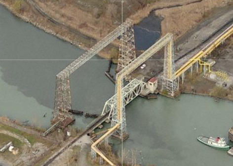
Plus the pipwork arches around Short Cut Bridge would make a great backdrop. By the way, that's the Delray Connecting Railroad going across Short Cut Bridge, which Jeff Knorek also
mentions on his site. Doesn't that water look inviting!
Next along the line is Detroit Edison's Belanger Park Power Plant. That's a big 'ol pile of coal heaped out back, so no second guesses as to how DTE generates juice there. That's our one-legged wye just to the west.
Luckily for my modeling purposes, the main route of the Marsh Track never actually comes too close to the Belanger Park plant. Unit trains exit the wye, cross over the CN (ex-GTW) and then reverse into the receiving yard just north of Belanger Park Dr. So, that's an entire industry I'd shuffle to the backdrop. There's even a handy berm separating the railroad right-of-way from DTE property where the tracks can magically disappear.

Right next door is a large steel plant, but Mr. Knorek's website is silent about all the industries south of Belanger Park, so from this point forward I'm operating on scientific wild ass guesses. Judging from the nearby street names, I'd say this is the Great Lakes Works' finishing plant in River Rouge. A quick Google search indicates that the Delray Connecting Railroad serves this plant, as well as the other Great Lakes Works facilities to the south. There's clearly a switch connecting the Conrail/CN trackage to DCR rails just to the south of the Belanger Park power plant switch, and Belanger Park Dr. separates the Great Lakes Steel receiving yard from its DTE equivalent.
An industry this large pretty much demands to be put onto the backdrop, but the only trick will be hiding the tracks, though the small white building next to Belanger Park Dr. - together with some creative landscaping - might do the trick. It seems worth the hassle because of the possibility of interchange traffic with the DCR and its steel industry traffic - bottle trains, finished steel products, and coke from Zug Island.
The DCR parallels the Marsh Track through an S-curve and into the Great Lakes Works in Ecorse. There's another interchange with the DCR at the top right of this photo, and then the Marsh Track diverges to the west while the DCR enters a maze of industries. None of this is served by Conrail, but would make some interesting backdrop fodder.
Slightly further south, the DCR emerges from the Great Lakes Works once again for yet another point of interchange. There's also a series of crossovers that connects the DCR to CN's South Yard, just out of the picture to the left.
We've reached the end of the line, Conrail's Tecumseh Yard. The picture to the left is rotated 90 degrees, so that north is to the right. That's Tecumseh Yard smack dab in the middle, with CN's South Yard just to the west. There's a switch on the Marsh Track line just north of Tecumseh Yard that provides an interchange with the CN. You may also notice another spur off the yard ladder that swings eastward around the southern edge of Great Lakes Works. I'd suspect this is yet another point of interchange with the DCR.
This would be a relatively painless yard to model - it's relatively small and selective compression should be pretty easy. From an operational perspective, it's got the potential for lots of interchange traffic from the DCR and CN.
So that's it! Everything you ever wanted to know about the Conrail Marsh Track and my thoughts on modeling it. It's quite remote from the rest of the railroad, however, and strays a little bit from my basic premise - original DTRR territory, taken over by Conrail, and returned to a reincarnated Detroit Terminal. So, I probably wouldn't include this area initially, but it's something to keep filed away for future reference.
In my next post, I'll consider the Conrail Junction Yard Secondary, which would connect the Marsh Track to the rest of the Detroit Terminal.


No comments:
Post a Comment